Oceanographic Survey
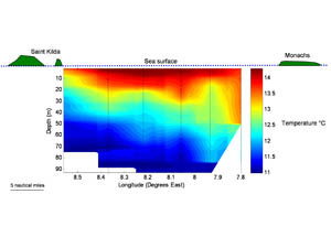
On the way from Saint Kilda to the Monachs, we conducted an oceanographic survey to measure the temperature and salinity of the water from the surface down to 100m depth. We did this by stopping every five miles to lower a CTD (which measures Conductivity, Temperature and Depth) into the water. Conductivity is used to calculate salinity at a given temperature and depth. A single transect can tell us about the structure of the water column and how it varies in space and will also add to the vast collection of data we collect and use to understand how our oceans work and how they are changing.
In the figure above we are looking at the temperature of a slice of the ocean from west to east. Saint Kilda is off to the left hand side and the Monach Isles are to the right. Black lines mark the location of CTD casts. In general, the warm (warmer than 13°C) water is confined to the surface ten metres near Saint Kilda but reaches 50m inshore at the Monachs. Surface warmth comes from solar heating, and the depth to which it will penetrate depends on how quickly cooler water is being mixed up from below. Strong currents supplying cooler water to Saint Kilda prevent the warm water from mixing down as far as it can in the shallower inshore water. There is a lens of water warmer than 14°C present in the four middle casts to up to ten metres deep where the warmth of the sun on a calm day has been able to penetrate relatively far. Heat appears to have been allowed to mix down further on the right hand side near the Monachs as there is less inflow of cool water where the water depth is shallower.
The oceanographic environment of the Hebrides is very dynamic, changing over a time scale of hours thanks to the influence of tides and wind. It is important that we continue to monitor longer term changes in the current system that might be associated with a changing global climate by compiling observations such as these.







No Comments