
Glaciers rock!
By Carol // Wednesday 3 Oct // 19:30:05 // No Comments
[photopress:MB_IMG_2739.jpg,full,pp_image]
[photopress:CC_gyre.jpg,full,pp_image]
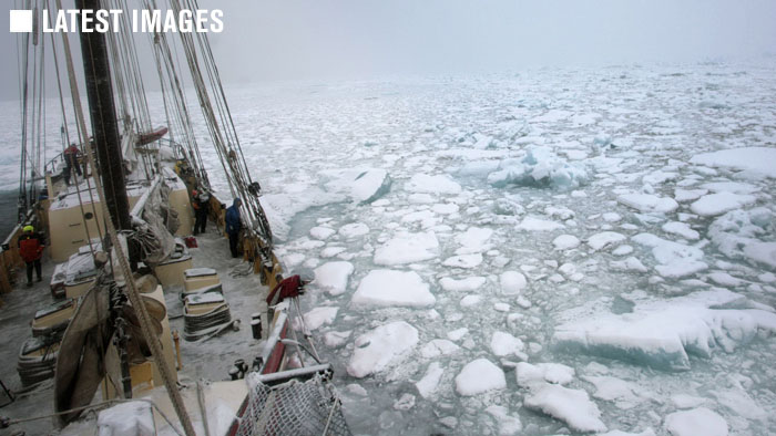
As a non-sailor, coming across the Greenland sea was surprisingly exhilarating. Weirdly, the increasing sense of exhilartion appeared to be exponetially linked to a worsening sea state (although my mum will never believe that in a month of sundays!) But now I’m seeing my glacial geomorphology textbooks come to life in a huge, towering, awe-inspiring way.
On the 2nd we went for an afternoon walk on a large moraine complex. One glacier fed into the head of the current fjord, in a north-easterly direction, and yet the east / west orientated striations on virtually all the boulders contained in the moraine suggested that something had come through from a different direction, exerting huge forces that gouged out lines in the solid rock. On climbing up to the top of the ridge I could see another glacier in the far distance, separated from the first one we could clearly see from the boat by a sharp ridge (arete). This glacier has retreated a long way up its valley, and yet with a bit of imagination and going back a few hundreds of years, you could visualise how these two streams of ice would have met, and carved their way out to sea in one massive ice stream. What I had thought to be a lateral moraine would actually have probably been a medial moraine, marking the join between the two glaciers.
On the 3rd we went for an amble in the Nooderlicht. Initially out to investigate a large iceberg, but then through a sound (Sund) round Turner Island. We went into a little inlet part way through the sund in which we were meant to moor last night. Here we saw something I thought I would never see in all my life – snap freezing of the sea within minutes – read Simon’s blog for more detail on this amazing feat of nature.
At the head of this cove was a classic example of a corrie or cirque. This is an amphitheatre shaped depression, usually located high up in the face of a mountain. It acts as an accumulation zone for snow, and will often develop into the head of a glacier. There was no obvious glacier forming in this one, although a trail of snow leading from it suggests that maybe in the past it was a glacial source. Following the snow down from this, there was a sudden drop into a lower valley, where a small glacier was retreating back from the fjord edge. Although not a classic example, this closely resembled a hanging valley, formed when a tributary glacier joins a main ice stream, and is quite literally left hanging when the main ice sheet retreats. What I couldn’t tell from the boat was when this retreat happened – whether or not the retreat has happend recently (on the geological timescale of hundreds of years!) or as part of a natural cycle of advance and retreat.
The sund also showed the effects of compression from the most recent period of Greenland’s evolution. Offshore there are lower tertiary volcanic rocks exposed at the seabed, whilst onshore we can see picrite volcanics, that formed sometime between 400 million years ago and the present (Devonian to the Quaternary). Turner Island, to our left (east, port-side) as we sailed through the sund showed beds dipping steeply to the east / south-east. To the west of us (off the starboard side) the beds were dipping more shallowly in the opposite direction. My immediate thoughts were that during the phase of compression and orogeny, linked to the building of the mountains surrounding us, there had been an uneven distribution of forces, resulting in the rocks being pushed up more steeply on one side. This could have
resulted from a geological barrier located offshore somewhere, inhibiting movement eastwards. It’s a bit of a leap of the imagination, but my mind is wandering through all possible connotations that would result in this. One option is the following, and I would welcome comments on this as I may be completely off base here! Compressive forces from the west during the orogenic phase were counter-balanced by seafloor spreading at the mid-ocean ridge to the east, causing this large scale anticline (upward doming fold) to form.
What was also obvious here was the offset between each limb (side) of the fold. The points of maximum dip appeared to overlap forming an “x”. But again a quick check of the maps (as frustratingly I couldn’t get ashore to investigate myself) showed a couple of transform faults run through the sund. The rocks have therefore slid past each other laterally at some point following the period of compression, in a north north-east / south south-west direction, breaking the folds.
The next page of the geology textbook to reveal itself was a couple of hours sail away, in another inlet located about 5 – 10 miles south. We passed a towering lateral moraine – another remnant of a much larger glacial outpouring, and saw this curling spit that appeared to flow out from the mountains on the other side of the inlet’s mouth. From the boat, my idea was that the constant erosion of the large moraine by ocean currents was carrying loose debris to the southerly side of the fjord, and depositing it in this curling spit of land. However, we could get ashore this time, and my idea as to its formation changed.
Walking along the spit we could see that it was made up of morianal type debris, but any visible striations on the boulder sized debris contained within it were very randomly orientated. At the landward end of the spit was a large debris fall, completely different in composition from the mountains either side of it, conaining a wide mix of grain sizes from very fine silts to large boulders about 4 foot in diameter. I couldn’t access the top of the debris flow (polar bear dangers combined with snow and ice), but I’ve seen something very similar in the Leones Valley in Chile. At the seaward side of this fall was a stream that tumbled down from the mountains in a series of waterfalls. This supported idea number 2!
Up in the mountains I believe there is a retreating land terminating glacier. As it retreats, a glacial lake forms behind the terminal moraine. This finally breaches, resulting in a mass debris flow as the meltwater carries the remains of the terminal moraine downslope. The stream still running down one side of the debris flow suggests that there is still a glacial meltwater source up in the high mountains. The debris is now being slowly re-worked by the continental shelf currents, with the shallow topography of the fjord to the north causing refraction of these currents into this inlet. This has resulted in a gyre like circulation around the inlet, that caused the re-worked sediments to be moved into the graceful curve we walked along today.
I’m sure that the next few days will bring more of my geology lessons to life…….and I eagerly await trying in vain to describe the wonderful formations and glacial geomorphology I’m seeing.
Tags: Carol Cotterill